


Rwanda has set target to reach a middle- and high-income status by 2035 and 2050 respectively.
To pave the way, the 2020 National Land Use and Development Master Plan (NLUDMP 2020-2050) was adopted with a motto of “Ensuring tomorrow’s sustainability today!”.
The ambitious NLUDMP ideals were encapsulated in the word “COOPERATE” which stands for: Consolidated development, Orderly planning, Openness for innovation, Preservation of nature, Economic yields, Rational urbanization, Ambient services, education, and healthcare, Transportation for all, Employment all over.
After design of the master plan, implementation phase followed without further due, thanks to compliance by different national projects and the development of 27 resulting districts land use master plans in addition to the city of Kigali and secondary cities new master plans in place.
The National plan has set optimal spatial boundaries for cities, urban centres and rural settlement sites for each district according to population target to guide urbanization development going forward.
The plan guides the future urbanization in the following hierarchy:
Kigali City as the capital city of Rwanda, surrounded by three satellite cities of Bugesera, Rwamagana and Muhanga forming the Golden Triangle and supported by 8 Secondary cities of Rubavu, Musanze, Huye, Rusizi, Nyagatare, Karongi, Kayonza and Kirehe cities at the peripheries/borders, and 16 district towns supplemented by 73 small rurban centres.
Musanze city at night which, among others, embodies tourism and urban area
The new move is that the entire District land use master plan will include urban and rural parts in one integrated plan to guide the densification that Rwanda needs for cities and to facilitate the progressive elimination of unplanned settlements in city peripheries.
“With the Master Plan, in the past, some residents fled the planned cities and went to settle in their suburbs which were not planned. It became compelling that developing a revised Land Use and development master plan was imperative to tackle existing land development and urbanization issues,” said Alexi Rutagengwa, Head of Land Use Management and Mapping Department at Rwanda Land Management and Use Authority.
According to Rutagengwa, so far, urban boundaries and rural settlement sites have been defined in all the thirty districts of the country and every other detail will be developed within.
The plan includes land allocation for every sector from national level and customised to district level in a zoning way.
Currently, he said, the on-going exercise is elaborating all districts land use plans starting with districts that host secondary and satellite cities.
Rwanda Land Management and Use Authority by closely working with districts and concerned stakeholders started detailed district land use plans with Muhanga, Huye, Nyagatare, Gicumbi, Gisagara and Musanze. The plan development approach is participative.
“This exercise includes more detailed zoning within and outside of the urban boundaries, but in general, every land in the country is dedicated to a specific use to be respected by implementers,” Rutagengwa said.
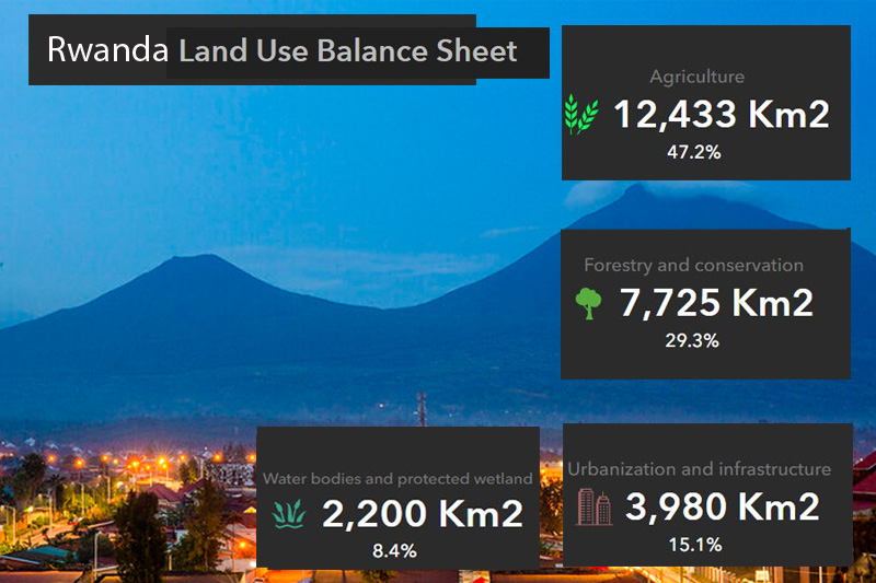
With this district zoning plan, every Rwandan citizen can already see where their land belongs in the following zoning categories: Residential, Commercial, Industrial, Public Facility, Public utility, Public administration, Transportation, Agriculture, Forest, Open space, recreational park and eco-tourism, wetland, water body and buffer.

Akagera national park. Land dedicated to park-tourism was demarcated
Coming next in this planning are Bugesera, Rwamagana, Rubavu, Rusizi, Kirehe, Karongi, Kayonza, Kamonyi and Rutsiro districts.
“These plans promote integrated planning, medium and high densities, mixed-use, mixed-income, housing incremental development, land consolidation and green urbanization approaches.” Rutagengwa said.
After this work, Rutagengwa finds it is important for the central, local government and community to ensure proper implementation of the land use master plan towards achieving the “Rwanda we want.”
For everyone who needs to know where their land belongs, they can use the National Spatial Data Infrastructure Hub (NSDI Hub) via www.geodata.rw and click on land Use Master Plan then follow instructions to pop-up Kigali City and each district zoning map.
Alternatively, one can use a mobile phone by *651# then put the UPI number of the plot. You then know what your land is dedicated to.